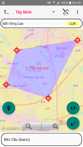
Features QH sử dụng đất Tây Ninh
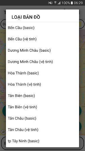
- Support to look up the land use planning of the districts.- Ben Cau, Duong Minh Chau, Hoa Thanh, Tan Bien, Tan Chau, Tay Ninh city, Trang Bang, Go Dau.- Using Mapbox.coms basemap technology on published land use plans- Determine the users current location on the land use planning map- Use 02 coordinate systems Longitude, Latitude and coordinate system VN2000- Support map zoom function, rotate Map in North-South axis- Find and save the coordinates of the current position- Electronic compass (only supports devices with magnetic induction chip)- Support for customizing transfer calculation parameters- Save and Display points, areas by Object, Project- Change color, hide and show objects and points in the Project- Save the free drawn area- View, Edit, Delete, Find Landmarks- Function to navigate to objects, save points- Support the function to redraw survey route over time- Support function to display map styles from mapbox.com- Draw Points, Polygon Domains; Measure Distance, calculate Area- Export point data into .kml .gpx .
file types- Support import point data from .gpx .
file- Send and exchange data of save points- Supports conversion tools between coordinate systems
Gaming Features
Enjoy immersive gaming experience with various game modes.
Lifestyle
Enhance your lifestyle with personalized tips and features.
Smart Home
Control and monitor your home with smart features.
See the QH sử dụng đất Tây Ninh in Action
Get the App Today
Available for Android 8.0 and above